views
‘Gigantic jet’ lightning is a mystery. These researchers are solving it.
Listen5 minComment on this storyCommentGift ArticleShare
An ordinary lightning bolt can be startling enough, but researchers are unlocking the secrets behind a rarely observed species of electrical discharge called “gigantic jets.” These are extraordinary bursts of light from the top of clouds that can brush up as high as the edge of space.
Only five observations of these jets are made in an average year, usually by accident. Sometimes lucky photographers capture them in long-exposure images, and once in a while they’re spotted by weather satellites.
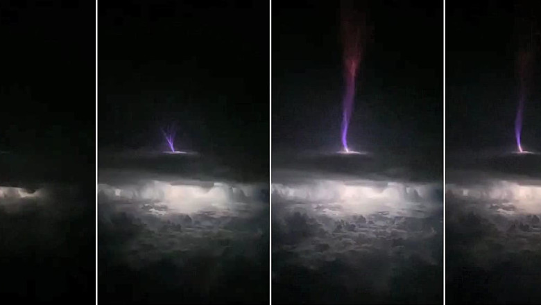
A study published Wednesday in the journal Science Advances sheds light on the structure and cause of gigantic jets. It analyzed a jet unleashed in Oklahoma on May 14, 2018, which shot up 50 miles above a storm cloud and distributed more charge than 100 traditional lightning bolts. It was the most powerful gigantic jet studied.
Researchers mapped the jet in 3D and identified structural features in greater detail than ever before.
Elusive red sprites, like glowing jellyfish in the night sky, photographed in Oklahoma
The investigation was inspired when Levi Boggs, a research scientist at the Georgia Tech Research Institute and one of the paper’s lead authors, learned about a photograph of the Oklahoma jet by a citizen scientist.
“Kevin Palivec [the photographer] has a l0w-light camera in Central Texas that he sometimes randomly operates, and he had captured this a couple of years ago,” Boggs said. The picture “was kind of sitting around. I was told about it and I decided to investigate a little bit.”
That’s when Boggs assembled a team that reviewed satellite, radar and radio-wave data to reconstruct what had happened.
The researchers were able to develop a model of the jet in 3D since it was seen by two satellite-based optical lightning instruments, including the lightning mapping array on the GOES-15 weather satellite that peers down over the eastern United States.
“I think it discharged an area approximately 50 kilometers by 50 kilometers within the cloud,” Boggs said. “It transferred that charge to the ionosphere,” the atmospheric layer about 50 to 400 miles above the Earth’s surface.
Steve Cummer, professor of electrical and computer engineering at Duke University, was able to extract high frequency electromagnetic data from a series of nearby antennas in the vicinity of the storm. For the first time, he was able to confirm that the high frequency signal emitted by lightning can actually be traced back to small tendril-like “streamers” of electricity at the tip of a propagating lightning channel.
Ground-based lightning detection networks also came in handy in investigating the jet, since they informed lightning rates in the storm before it was unleashed.
“We were able to determine the peak currents and type of discharge for the parent storm,” Boggs said.
Strangely, Boggs said, there were no conventional lightning strikes in the immediate region that produced the gigantic jet. He has a theory about it that’s tied to the jets’s most common location: over ocean rather than land.
Thunderstorms typically exhibit a tri-polar electric field, meaning they consist of a positively charged area near the ground, a negatively charged area near the bottom of the cloud and a positively charged area near the cloud top. The contrast between the negative charge at the bottom of the cloud and positive charge near the ground triggers lightning.
“What happens is there’s a suppression of these cloud-to-ground discharges,” Boggs said.
This suppression of cloud-to-ground strikes happens most frequently with ocean storms for reasons scientists still don’t understand, Boggs said.
The researchers found that, in the absence of a charge contrast between the cloud and surface, negative charge builds up in the clouds. Gigantic jets may then relieve that excess negative charge.
Some of the most prolific episodes of gigantic jets have been noted over tropical storms or hurricanes — which are notoriously bereft of ordinary lightning. On Aug. 11 and 12, 2015, Hurricane Hilda produced a barrage of enormous jets as it slipped southeast of Hawaii.
There are still plenty of things that remain undiscovered and unknown in the field of gigantic jets, which falls under the umbrella of TLEs, or transient luminous events — i.e., upper atmospheric lightning.
“We still don’t really know how frequently they occur,” Boggs said. “There are about five detections of gigantic jets per year, but we’re hoping to get maybe tens of thousands.”
To do so, Boggs and his team are working on a machine learning algorithm to integrate into the satellite-based geostationary lightning mapper data.
“We just haven’t seen them because observations are so limited,” Boggs said. “It’s really tough to coordinate with instruments in orbit, so we have a [National Science Foundation] grant that’s coming up soon. That will basically use [satellite data] to hunt for these gigantic jets in huge quantities … hopefully we’ll be able to detect these things across a hemisphere hopefully 24 hours a day.”
#GOESEast's Geostationary Lightning Mapper has captured the first images from space of 'GIGANTIC JET' #lightning - electrical discharges from a thunderstorm that come out the TOP of the storm and reach as high as the ionosphere (50 miles up)! Learn more: https://t.co/V5eXtcHDDK pic.twitter.com/UCQGWFUsvk


Comments
0 comment